
Before the Water: The Story of Paintsville Lake’s Lost Valley
When you visit Paintsville Lake today, it’s hard to imagine the rugged, flood-prone valley that once existed beneath its tranquil surface. But before the lake was created in 1983, this corner of eastern Kentucky was shaped by its dramatic geography, deep-rooted Appalachian culture, and a long history of battling the elements.
A Land of Hills, Valleys, and Early Settlers
The Paintsville Lake region, stretching across Johnson and Morgan counties, was once a tapestry of steep hills, winding valleys, and dense forests. Paint Creek, a tributary of the Levisa Fork of the Big Sandy River, carved its way through the landscape, making the area both beautiful and vulnerable to flooding.

Settlement here dates back to the late 1700s. Paintsville itself, originally known as Paint Lick Station or Paint Landing, was referenced as early as 1780, though it wasn’t formally chartered as a town until 1834. Early families—Preston, Remy, Dixon, Huff, Franklin, and Auxier among them—built their lives on small farms tucked into the hills. These settlers were often of Scotch-Irish, English, or German descent, bringing with them the traditions and resilience of Appalachian pioneers.
Centuries before Europeans arrived, Indigenous peoples, including the Adena mound builders, called this valley home. The name “Paint Creek” comes from Native American pictographs once visible on trees and rocks along the creek, a reminder of the region’s ancient past.
The Floods That Changed Everything
Life in the Paintsville area was always at the mercy of the water. The valley’s geography and frequent heavy rains meant that flooding was a constant threat. Some of the worst floods—especially those in 1937, 1957, and 1977—left a trail of destruction, washing away homes, isolating towns, and causing millions in damages. The 1957 flood was so severe that hundreds of families had to be evacuated, and the 1977 disaster led to a federal disaster declaration across eastern Kentucky.

These repeated catastrophes made it clear that something had to change. While the construction of Dewey Dam in 1949 offered some relief, it wasn’t enough to fully protect Paintsville and its surrounding communities. By the 1960s, the idea of damming Paint Creek itself began to take shape, despite controversy and concerns about the impact on local residents.
Life in the Valley Before the Lake
Before the dam, the Paintsville Lake area was a patchwork of small farms, scattered homesteads, and thick forests. Unlike other Kentucky reservoirs that swallowed up entire towns, this valley was mostly rural, with no major communities lost beneath the water. The Mountain Homeplace, now a living history museum at Paintsville Lake State Park, offers a glimpse into the 19th-century farming lifestyle that once defined the area.
People here relied on small-scale agriculture, timber harvesting, and some coal mining. The rugged terrain kept development modest, but the natural beauty of the cliffs and coves was always a source of local pride. Wildlife—deer, bears, and countless birds—thrived in the forests and along the creek.
Culture, Music, and Mountain Resilience
The Paintsville area has always been rich in Appalachian culture. Coal mining, timber, and farming shaped daily life, but so did music. Just a few miles away is Butcher Holler, birthplace of country music legend Loretta Lynn, a testament to the region’s deep musical roots.
Communities here were tight-knit and resilient, shaped by generations of hard work and by the constant challenge of living with nature’s unpredictability. The repeated floods fostered a sense of unity and ultimately, support for the dam project, which promised both safety and new opportunities.
The Transformation: From Valley to Lake
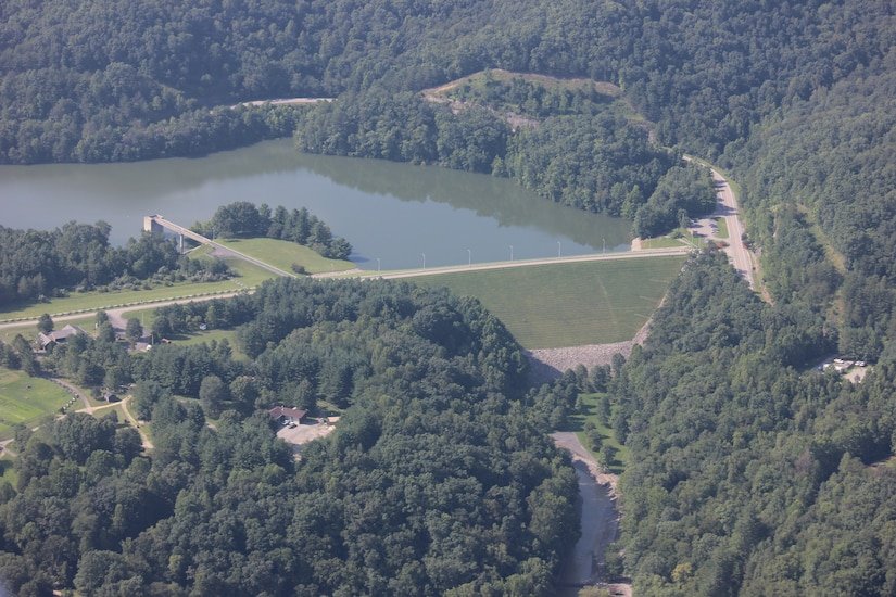
Construction on the Paintsville Lake Dam began in the late 1970s, led by the U.S. Army Corps of Engineers. There were tense moments—like in December 1978, when a leak in the coffer dam forced the evacuation of 10,000 residents. Thankfully, the dam held, and the project moved forward. The main dam was completed in 1980, and by 1983, the new 1,139-acre reservoir was open to the public.

The creation of Paintsville Lake brought dramatic change. Flood risk was reduced, and the area was reborn as a destination for fishing, boating, and outdoor recreation. Paintsville Lake State Park was established in 1986, and the dam has since prevented hundreds of millions of dollars in flood damages, though flash flooding remains a concern.
What Was Lost—and What Remains
While there are no well-documented “ghost towns” beneath Paintsville Lake, and the valley was less densely populated than some other flood-control projects in Kentucky, the transformation still came at a cost. Some families were displaced, and farmland was lost to the rising water. The full human story—of those who left, and of the communities that adapted—remains only partly told, waiting in local archives and family memories.

Today, Paintsville Lake stands as both a symbol of resilience and a reminder of the valley that once was—a place where history, culture, and nature continue to shape the heart of eastern Kentucky.
Want to learn more? Camp, Fish and ENJOY IT! Visit the Mountain Homeplace or Paintsville Lake State Park to experience the region’s living history for yourself!
